
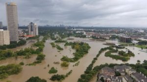
Memorial Heights in west Houston, Texas.
Credit: Aaron Cohan
Since Houston, Texas was founded nearly two centuries ago, Houstonians have been treating its wetlands as stinky, mosquito-infested blots in need of drainage.
Even after it became a widely accepted scientific fact that wetlands can soak up large amounts of flood water, the city continued to pave over them. The watershed of the White Oak Bayou river, which includes much of northwest Houston, is a case in point. From 1992 to 2010, this area lost more than 70% of its wetlands, according to research (pdf) by Texas A&M University.
In the false-color satellite images below, plants and other vegetation appear green, while urbanized and developed areas appear blue and purple. Drag the slider to see how northwest Houston has changed since 1986.
In recent days, the flooding caused by Hurricane Harvey has raised water levels in some parts of the watershed high enough to completely cover a Cadillac. The vanished wetlands wouldn’t have prevented flooding, but they would have made it less painful, experts say.
The Harvey-wrought devastation […]


My understanding is Houston has little or no zoning and the Texas belief that “bidness” knows best and should not be burdened with regulations only makes awful worse. These disasters will become the US military’s new mission as climate warming is seen as the true enemy, at least I hope so. We humans may learn that we are all in this together-one planet, one species, one need to survive. F35 fighters and new next-gen aircraft carriers are worthless…
Houston is an atmospheric compression event caused by the Grand Solar Minimum. The last time we had large storms was during the low spot in the previous solar cycle.